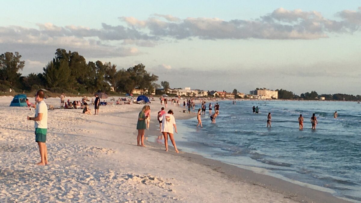
2022 season storms brought extensive and expensive damage to parts of Florida and Puerto Rico. Anna Maria Island experienced a relatively quiet season with the exception of Hurricane Ian. Storm damage was mainly to roof shingles and soffits in the 40-80mph winds.
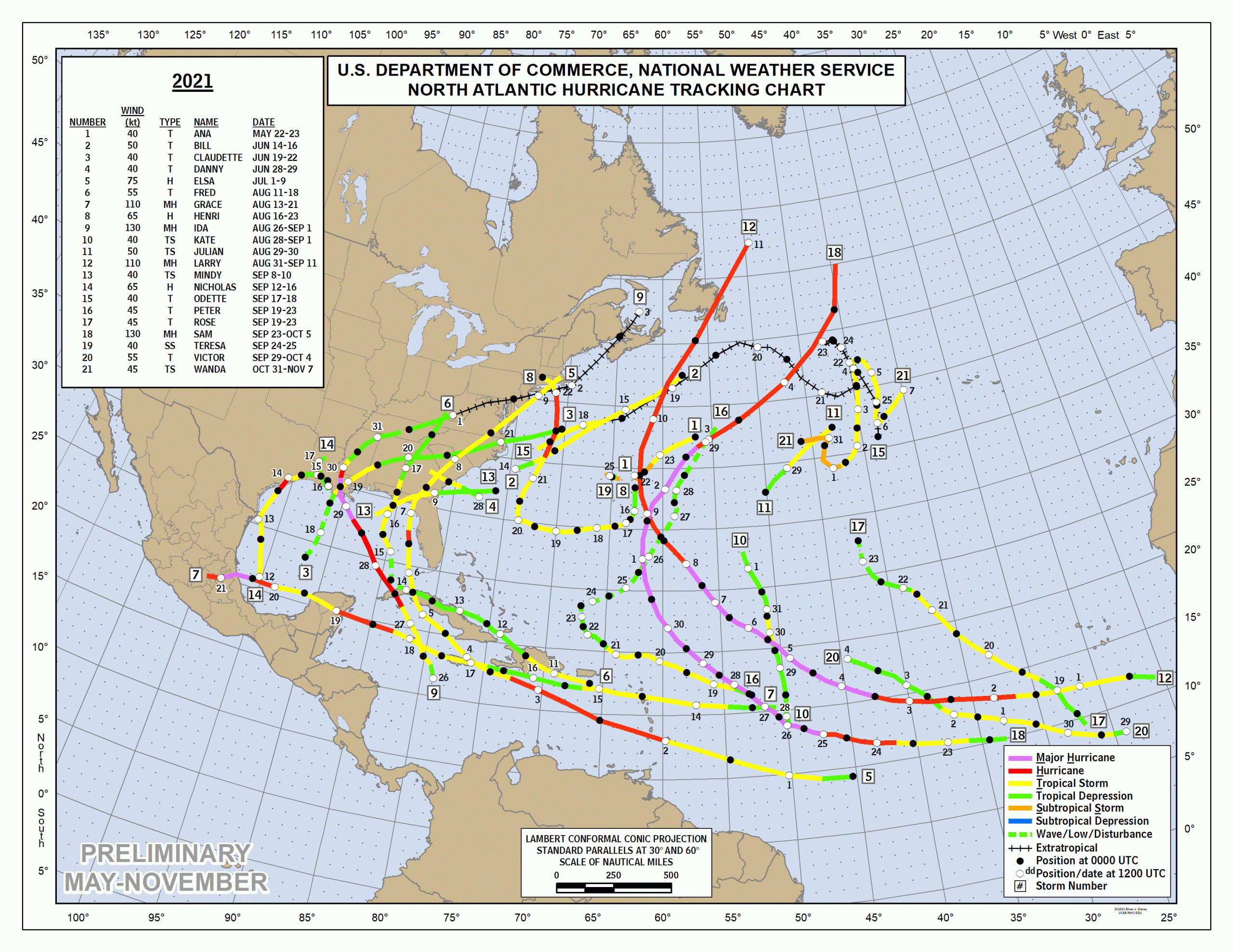
There were 14 named storms of greater than gale force wind, same as recent year average. Of these, eight intensified to hurricane strength of over 72 mph, two of these became major hurricanes of over 111 mph sustained winds. Notably, August was the first time since 1997 that there was no storm at all.
Hurricane Ian tied for the fifth-strongest hurricane ever to make landfall in the U.S., at Category 4 with 150 mph maximum sustained winds. Ian posed a severe threat to the southwest coast of Florida as it intensified after crossing the Dry Tortugas of Florida Keys September 28, then slammed into Costa Cayo near Punta Gorda, transited central Florida and exited the state at Cape Canaveral. It then continued north and made a third landfall at Georgtown South Carolina.
Hurricane Fiona made landfall as a Category 1 at Puerto Rico.
Hurricane Niccole was the season’s third U.S. landfall at Hutchinson Island Florida as a Category 1.
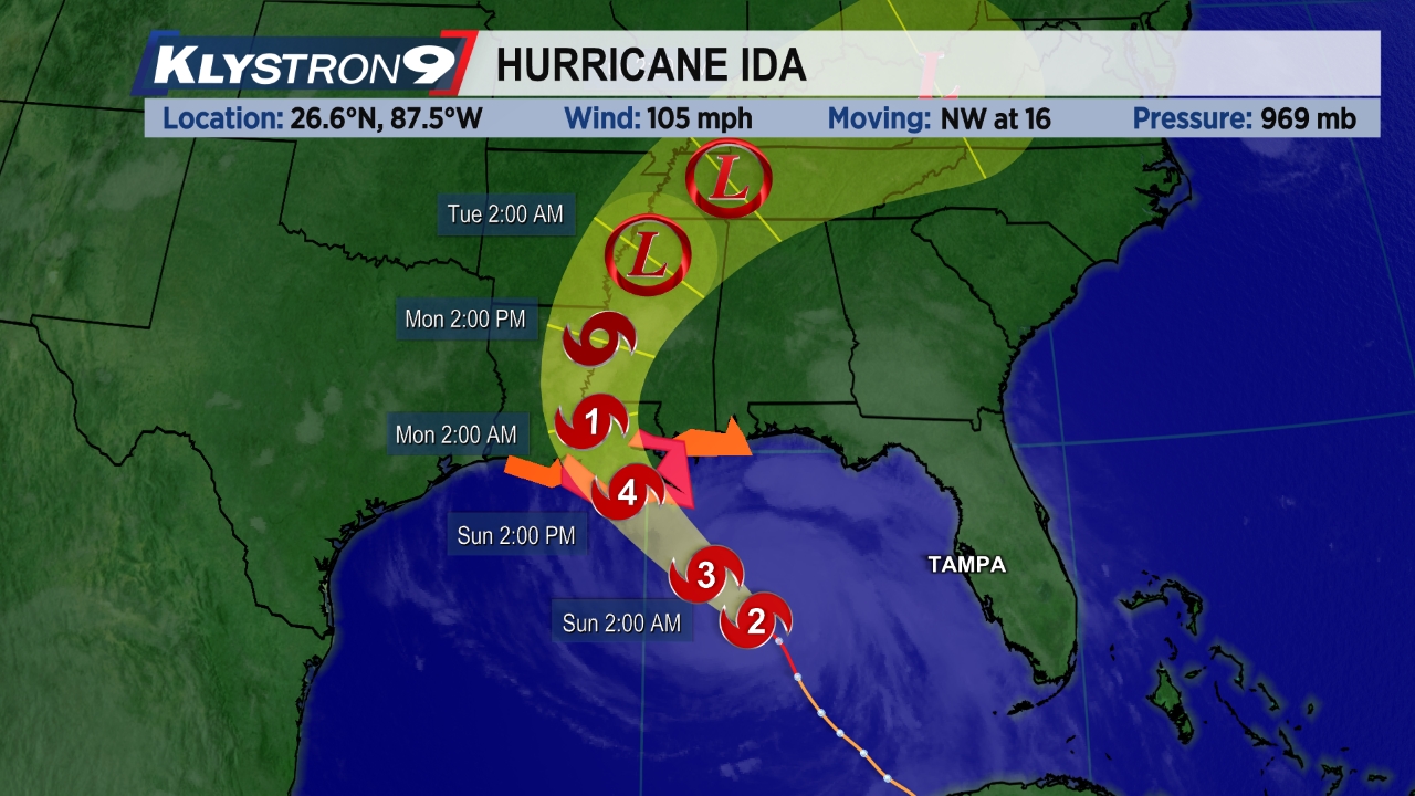
The forecast trajectory of Hurricane Ian put Anna Maria Island on watch several days ahead for proximal impact. The storm strengthened as it traveled up the west gulf coast. Expectations of a major catastrophe were in everyone’s minds as residents prepared to evacuate inland.
Authorities issued mandatory evacuation orders, meaning local emergency services would not be available if people stayed. Usually the loss of electricity can be expected but alternative resources can be planned. Controversially they ordered the water supply shut off early in the days before the storm’s forecast arrival. Once off the island, return would require an official permit. Most people evacuated whether they wanted to or not.

As the forecast path fluctuated left and right, the angle of approach made projected landfall vary by 100’s of miles. Being on the east or west side of a counterclockwise rotating hurricane center can make a huge difference in wind strength and resultant impact.

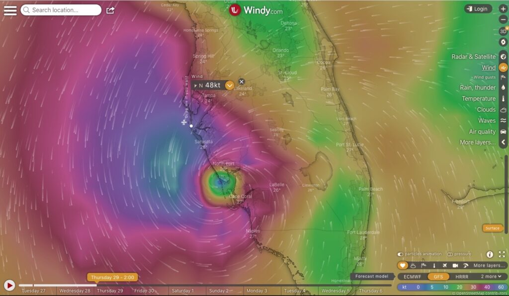
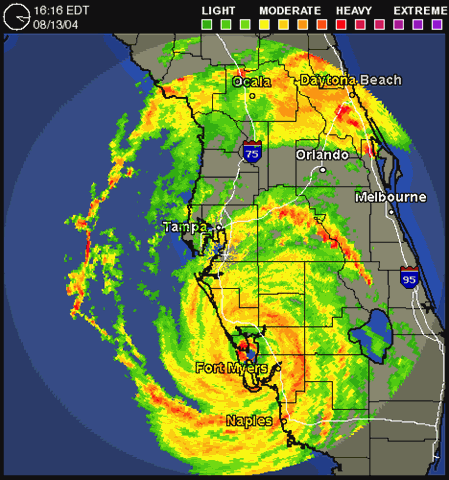
Similarly to Hurricane Charley in 2004, Hurricane Ian trended right during the last few hours before landfall, lashing Anna Maria Island with gusty winds from the north but little rain, and no storm surge, while exploding into Captiva Island 70 miles south, leaving a devastating wake of crushed and submerged houses, downed trees, washed out bridge to the mainland, and flooded cars and boats over a wide swath from Fort Myers to Port Charlotte and inland. Storm surge was reported to be up to 18 feet above sea level. 114 people died.
Hurricane Nicole made an east coast landfall near Vero Beach, Florida, with 75 mph (120 km/h) sustained winds. Nicole then weakened to a tropical storm inland, as it moved across Central Florida. Later that day, its center briefly emerged over the Gulf of Mexico, north of Tampa, before moving onshore again northwest of Cedar Key. Impact on Anna Maria Island was minimal.

Complete List of Storms 2022
| Name | Date | Cat | Max wind mph (km/h) | Areas affected | Deaths |
|---|---|---|---|---|---|
| Alex | June 5–6 | TS | 70 (110) | Yucatán Peninsula, Western Cuba, Florida, Northern Bahamas, Bermuda | 4 |
| Bonnie | July 1–2 | TS | 50 (85) | Trinidad and Tobago, Grenada, Colombia, Venezuela, ABC Islands, Central America (before crossover) | 4 |
| Colin | July 1–2 | TS | 40 (65) | South Atlantic United States | 1 |
| Danielle | September 1–8 | Cat 1 | 90 (150) | Western Iberian Peninsula | None |
| Earl | September 3–10 | Cat 2 | 105 (165) | Northern Leeward Islands, Puerto Rico, Bermuda, Newfoundland | 2 |
| Fiona | September 14–24 | Cat 4 | 130 (215) | Lesser Antilles, Puerto Rico, Dominican Republic, Eastern Bahamas, Turks and Caicos Islands, Bermuda, Eastern Canada | 31 |
| Gaston | September 20–26 | TS | 65 (100) | Azores | None |
| Ian | September 23–30 | Cat 4 | 155 (250) | Trinidad and Tobago, Venezuela, Colombia, ABC islands, Jamaica, Cayman Islands, Cuba, Southeastern Coast of the United States | ?157 |
| Hermine | September 23–25 | TS | 40 (65) | Canary Islands | None |
| Eleven | September 28–29 | 35 (55) | None | None | |
| Twelve | October 4–7 | 35 (55) | None | None | |
| Julia | October 7–9 | Cat 1 | 85 (140) | Trinidad and Tobago, Venezuela, ABC Islands, Colombia, Central America (before crossover) | 91 |
| Karl | October 11–15 | TS | 60 (95) | Southern Mexico | 3 |
| Lisa | October 31 – November 5 | Cat 1 | 85 (140) | Jamaica, Cayman Islands, Central America | None |
| Martin | November 1–3 | Cat 1 | 85 (140) | None | None |
| Nicole | November 7–11 | Cat 1 | 75 (120) | The Bahamas, Southeastern Coast of the United States | 11 |