Categories
Environment

2021 Atlantic Hurricane Season Forecast

2021 is likely to be “near normal” in terms of tropical activity, though there is more risk of an active season. Impacts from landfalling hurricanes could shift eastward this season toward the U.S. East Coast and the Leeward Islands. 

The forecast for the 2021 Atlantic Hurricane Season from June-November shows the likelihood for a near normal season, with 

  • tropical cyclone activity at ~107% of normal anticipated 
  • range of activity from 97-119% of normal 
  • 17 named storms (average 14)
  • 8 hurricanes  (average 7)
  • 3 major hurricanes (average 3)

Unlike last season, the 2021 outlook does not include a hyperactive season within the expected range of outcomes, though there is very little chance for below normal activity this season. It should be noted that a “normal hurricane season” now represents higher levels of tropical activity in all aspects because of the climatology update uses 1991-2020 as the baseline instead of 1981-2010 period used previously. If 2021 outlook was issued based on the previous climatology, the forecast would call for an active season instead of a near normal one. 
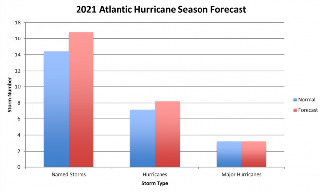
2021 Storm Forecast (red) compared to normal (blue)

The Greek alphabet will no longer be used to extend the named storms’ list. If all names in the first list have been used, a supplemental list will begin.

Background:
The major ocean basins’ data support a near to above normal season of tropical activity once again. Beginning with ENSO (El Niño Southern Oscillation), there is an 80% chance of neutral or La Niña conditions being in place by the August-October peak of hurricane season, with only a 20% chance of El Niño. 

La Niña is the most favorable state for active Atlantic seasons as it supports low vertical wind shear needed for tropical cyclone formation and intensification, so the strong likelihood of neutral or La Niña conditions in 2021 suggests an active year while the slight El Niño chance reduces that potential. 

The Atlantic Multi-decadal Oscillation (AMO) shows an 80% chance to be in its favorable warm Sea Surface Temperature (SST) phase for Atlantic tropical activity. 

The largest question is the Indian Ocean Dipole (IOD), which has a connection to Atlantic occurrence of dry air that suppresses tropical cyclone formation. In 2021, there are questions about the state of the IOD by August-October, which supports a nearer to normal hurricane season. 

The most reliable forecast variable is Accumulated Cyclone Energy (ACE), which is widely viewed as the best measure of cyclone activity instead of the total named storm number and hurricane number. Since tropical cyclones vary wildly in duration from 1-10+ days, similar numbers of storms in different years can still represent very different levels of activity. 

The spread among the storms is relatively narrow, with 20% of the years showing below normal activity while the other 80% showed above normal activity. Due to the narrow range among prior years relative to the new normal level of activity, 100% of the prior years used in the forecast are in the “near normal” range. This results in a high confidence outlook for near to above normal activity in 2021, with the direction of ENSO and the IOD being the key issues to monitor.  

The data used in the forecast and current SST anomalies both indicate the U.S. East Coast being at the greater risk for higher impacts than usual, based on warm ocean waters off the coastline. If the model holds, any developing tropical cyclone that moves across the Western Atlantic approaching the U.S. will have ample energy to become a high-impact hurricane if other environmental conditions allow. There is also a consensus for slightly warmer than normal SST around the Leeward Islands of the Caribbean Sea, making that another area to watch for high-end impacts this season. Gulf of Mexico SST is not low but  not near the record warmth of last year. 
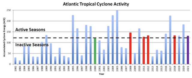
Annual Atlantic seasonal  tropical cyclone activity from 1982-2021, with 2000, 2008, 2011, 2012, and 2018 highlighted in red for active, green for inactive seasons (June-November), and the 2021 forecast highlighted in purple.
Annual Atlantic seasonal  tropical cyclone activity from 1982-2021, with 2000, 2008, 2011, 2012, and 2018 highlighted in red for active, green for inactive seasons (June-November), and the 2021 forecast highlighted in purple.
Categories
Environment

2017 Atlantic Hurricane Season Forecast


The season’s first updated June forecast for Atlantic hurricanes in 2017 has been released by the Colorado State University Tropical Meteorology Project.

(April 6 ) This year, 2017, the expectation is for a “below average” year, based on 29 years of observations from 1981 to 2010. There is the potential for shear-enhancing El Niño conditions to develop over the next several months. The tropical Atlantic has cooled over the past month, and the far North Atlantic is currently colder than normal. These cold anomalies tend to force atmospheric conditions that are less conducive for Atlantic hurricane formation and intensification.

(June 1) We have increased our forecast and now believe that 2017 will have approximately average activity. The odds of a significant El Niño in 2017 have diminished somewhat, and portions of the tropical Atlantic have anomalously warmed over the past two months. While the tropical Atlantic is warmer than normal, the far North Atlantic remains colder than normal, potentially indicative of a negative phase of the Atlantic Multi-Decadal Oscillation. We anticipate a near-average probability for major hurricanes making landfall along the United States coastline and in the Caribbean.

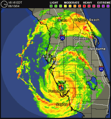
August 2004, Hurricane Charley washed out part of Captiva Island.

From http://tropical.colostate.edu :-

We anticipate that the 2017 Atlantic basin hurricane season will have slightly below- average activity. The current neutral ENSO is likely to transition to either weak or moderate El Niño conditions by the peak of the Atlantic hurricane season. The tropical Atlantic has anomalously cooled over the past month and the far North Atlantic is relatively cold, potentially indicative of a negative phase of the Atlantic Multi-Decadal Oscillation. We anticipate a below-average probability for major hurricanes making landfall along the United States coastline and in the Caribbean. As is the case with all hurricane seasons, coastal residents are reminded that it only takes one hurricane making landfall to make it an active season for them. They should prepare the same for every season, regardless of how much activity is predicted.
by Philip J. Klotzbach and Michael M. Bell (as of 6 April 2017)

An analysis of a variety of different atmosphere and ocean measurements (through March) which are known to have long-period statistical relationships with the upcoming season’s Atlantic tropical cyclone activity indicate that 2017 should have slightly below-average activity. The big question marks with this season’s predictions are whether an El Niño develops, as well as what the configuration of Sea Surface Temperatures will look like in the tropical and far North Atlantic Ocean during the peak of the Atlantic hurricane season.

June 1 – Our confidence that a weak to moderate El Niño will develop has diminished since early April. While upper ocean content heat anomalies have slowly increased over the past several months, the transition towards warm ENSO conditions appears to have been delayed compared with earlier expectations. At this point, we believe that the most realistic scenario for the 2017 Atlantic hurricane season is borderline warm neutral ENSO to weak El Niño conditions. There remains a need to closely monitor ENSO conditions over the next few months. Additional discussion of ENSO will be included with the July 1 and August 4 updates.

2017 Forecast numbers:

Atlantic Hurricane SeasonApril    June 2017 forecast29-year Median
Named storms (>35mph winds) 11         13
12
Hurricanes (>72mph winds) 4             6
6.5
Major hurricanes (>111mph winds) 2             22
US landfall likelihood42%        55%52%
Gulf Coast landfall probability24%        32%30%
Major Hurricane in Caribbean
probability
34%        44%42%
Manatee County hurricane landfall
probability
0.6%        0.7%0.7%
Manatee County tropical storm
probability
14.7%      18.3%17.1%
Manatee County >75mph wind gusts
probability
4.2%        5.4%5.0%
Tracks of major hurricanes making Florida peninsula and East Coast landfall during 1916-1965 and 1966-2015.
Tracks of major hurricanes making Florida peninsula and East Coast landfall during 1916-1965 and
1966-2015.
Categories
Environment

2011 Atlantic Hurricane Season Review


2011 Atlantic Hurricane Tracks

Highlights:

  • No effects on Anna Maria Island
  • No Florida landfalls
  • Slightly above long-term average named storms
  • 3 US landfalls, 2 in Gulf (Don, Lee, Irene)
  • Hurricane Irene caused extensive damage to east coasts states from NC to NY.