Red Tide Current Status:
Florida Fish and Wildlife Conservation Commission (FWC):
https://myfwc.com/research/redtide/statewide/
Mote Marine Laboratory:
https://visitbeaches.org/
Red tide algae bloom was detected on Anna Maria Island shores August 3, 2018, and affected air and sealife soon after. While the municipalities and county services cleaned up dead fish on the beaches, the irritating smell sent people to seek indoor relief and, as word spread, visitors cancelled their trips.
(Update September 5, 2018 below at end of article.)
The current bloom is from microscopic Karenia Brevis, an alga native to Gulf of Mexico, spreading north from Naples to Tampa Bay.
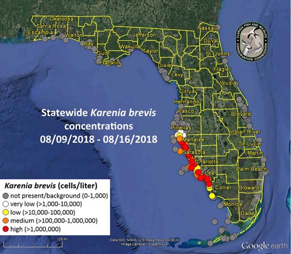
Dead fish started turning up in the bay-side waters and canals a few days ago, but not as prevalent as the last red tide fish kill in December, 2015, which lasted several weeks.


Since August 20, 103 manatee have died of which 29 tested positive for K. Brevis, and suspected in the 74 others. The manatee death toll so far this year from all causes has reached 554, compared to 527 for all of 2017.
Red tide also affects turtles and seabirds. “This year so far, we have rescued or recovered a total of 137 sea turtles,” said Hayley Rutger, spokesperson for Mote Marine Laboratory. “A lot of those were already deceased. Some of them were affected by humans, like boat strikes or entanglements in fishing gear, but some of them are suspected to have been affected by the ongoing red tide bloom.”
“Cormorants will dive through the water, and they’re basically diving right through the blooms so they’re getting it in their eyes and their faces and their mouths,” explained Avian Hospital Administrator Dana Leworthy. “They don’t necessarily need to ingest the fish to get the red tide.”
Although the Florida red tide is a naturally occurring phenomenon, agricultural and urban runoff can prolong red tide blooms inshore.


 The 2017 hurricane season was more active than predicted by the Colorado State University Tropical Meteorology Project forecast team. Three major hurricanes struck the United States: Harvey, Irma and Maria, causing devastating destruction to islands in the Caribbean and other portions of the tropical Atlantic:
