Categories
Environment

2020 Atlantic Hurricane Season Review

Summary:

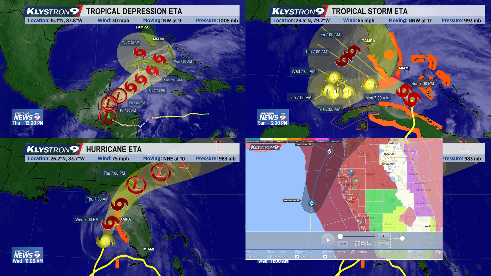
An active 2020 summer storm season passed by Anna Maria Island with minor effects. Hurricane Eta caused a surprisingly high storm surge and flooding overnight coinciding with a high tide. A local business man died from electrocution after touching a flooded appliance.

  • Above average storm activity
  • No Anna Maria Island evacuations
  • 2 landfalls on Florida Gulf Coast, Sally and Eta
  • Minor damage from Eta 2′ surge, which flooded some low-lying Anna Maria Island properties. Minor squalls and rainfall.
Fastest growing storms of 2020
US Mainland landfalls 2020

“I think really what stood out to me about 2020 was the extremely active late season. October and November were extremely active with seven storms and a whopping four major hurricanes (Delta, Epsilon, Eta and Iota).” said Phil Klotzbach, lead author of the forecast at CSU.

The causes of the active year, according to NOAA’s lead seasonal hurricane forecaster Gerry Bell, included warmer-than-average Atlantic sea-surface temperatures and a stronger west African monsoon, along with wind patterns coming off Africa that were more favorable for storm development. 

“These conditions, combined with La Niña, helped make this record-breaking, extremely active hurricane season possible.”

While it’s clear warmer ocean temperatures make storms stronger, there’s still vigorous debate among top climate scientists on the question of whether warmer waters lead to a greater number of tropical systems. 

 “My colleagues and I feel that the jury is very much out on the topic of global tropical cyclone frequency,” said Dr. Kerry Emanuel from MIT, a leading researcher on how climate change affects hurricanes. While this Atlantic season was extreme, he points out that what we see in the Atlantic Basin is not representative of the rest of the globe. “Only about 12 percent of the world’s tropical cyclones occur in the Atlantic, and globally it has not been a very exceptional year.”


Atlantic Hurricane Season
 April 2020 forecast 2020 Actual
Named storms (>35mph)       13  30
Hurricanes (>72mph)        8  13
Major hurricanes (>111mph)        4  9
US landfall likelihood    55%  40% (12)
Gulf Coast landfall    32%  30% (9)
Florida landfall 7% (2) Keys and panhandle

The Named Storms of 2020:

NameActive PeriodPeak Strength
mph
TS ArthurMay 16-1960
TS BerthaMay 27-2850
TS CristobalJune 1-1050
TS DollyJune 21-2445
TS EdouardJuly 4-645
TS FayJuly 9-1160
TS GonzaloJuly 21-2565
Hurricane HannaJuly 23-2790 (Cat 1)
Hurricane IsaiasJul 28-Aug 585 (Cat 1)
TS JosephineAug 11-1645
TS KyleAug 14-1650
Hurricane LauraAug 20-29130 (Cat 4)
Hurricane MarcoAug 20-2575 (Cat 1)
TS OmarAug 31-Sep 540
Hurricane NanaSep 1-475 (Cat 1)
Hurricane PauletteSep 7-23105 (Cat 2)
TS ReneSep 7-1450
Hurricane SallySep 11-18105 (Cat 2)
Hurricane TeddySep 12-24140 (Cat 4)
TS VickySep 14-1750
TS BetaSep 17-2560
TS WilfredSep 18-2140
TS AlphaSep 18-1950
TS GammaOct 2-670
Hurricane DeltaOct 4-12145 (Cat 4)
Hurricane EpsilonOct 19-26115 (Cat 3)
Hurricane ZetaOct 24-29110 (Cat 2)
Hurricane EtaOct 31-Nov 13150 (Cat 4)
TS ThetaNov 10-1570
Hurricane IotaNov 13-18160 (Cat 5)
Hurricane Laura track
Hurricane Laura track August 20 – 29, 2020, becoming Cat 3 near landfall
Tropical Storm Isaias July 28 – August 5, 2020
Hurricane Delta October 4 – 12, 2020
Hurricane Zeta October 24 – 29, 2020
Hurricane Zeta wind field October 28, 2020
Tropical Storm Eta tracked west into central America causing widespread damage then returned east to cause havoc to Cuba, the Keys, and then north off the Florida west coast as Cat 4 hurricane October 24 – 28, 2020, weakening at time of landfall.

For detailed discussion of factors contributing to 2020 storm weather, see CSU meteorology (pdf).

Categories
Environment

2018 Atlantic Hurricane Season Forecast


The 2018 extended range tropical forecast has been released updated by Colorado State University Department of Atmospheric Science.

As at April 5 July 2, the forecast is for slightly above average storm activity below average activity for the Atlantic Ocean basin. The current weak La Niña is not expected to transition into a significant El Niño by summer and fall. El Niño conditions create vertical wind shear that inhibits hurricane formation. Without wind shear, the tropical Atlantic is conducive to storm development.

We have decreased our forecast and now believe that 2018 will have below-average activity. The tropical and subtropical Atlantic is currently much colder than normal, and the odds of a weak El Niño developing in the next several months have increased. With the decrease in our forecast, the probability for major hurricanes making landfall along the United States coastline and in the Caribbean has decreased as well.

The forecast predicts a slightly above-average below average probability for major hurricanes making landfall along the continental United States coastline and in the Caribbean.
(full details at https://tropical.colostate.edu)

2018 Forecast numbers:

Categories
Environment

2017 Hurricane Season Review


2017 Named storm tracks

Summary:

  • Above average storm activity
  • Anna Maria Island evacuation for Irma, but no flooding, contrary to forecast 5′ – 15′ surge
  • 2 landfalls on Florida Gulf Coast (Irma and Philippe)
  • Broad swath of property damage, trees downed, and power outages across Florida from Irma
  • Minor damage to Anna Maria Island properties and trees. Maximum wind reported was 92mph as the eye of Irma traveled inland of the island
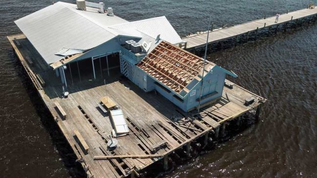
  • Anna Maria City Pier and restaurant damaged beyond repair
Anna Maria City Pier hurricane damage
Anna Maria City Pier hurricane damage Photo: Jack Elka, The Islander
Some Ficus, Banyan, Norfolk Pines blew over

The 2017 hurricane season was more active than predicted by the Colorado State University Tropical Meteorology Project forecast team. Three major hurricanes struck the United States: Harvey, Irma and Maria, causing devastating destruction to islands in the Caribbean and other portions of the tropical Atlantic:

“The 2017 hurricane season was extremely active. Overall, our predicted numbers from our early July and August issue dates for named storm and hurricane formations were relatively close to what was observed, but our early season predictions and our predictions for integrated metrics such as Accumulated Cyclone Energy (ACE) were far too low,” said Phil Klotzbach, lead author of the forecast at CSU.

Atlantic Hurricane Season April June 2017 forecast 2017 Actual
Named storms (>35mph) 11      13  16
Hurricanes (>72mph)  4       6  10
Major hurricanes (>111mph)  2       2  6
US landfall likelihood 42%   55%  31%
Gulf Coast landfall 24%   32%  13%

The Named Storms:

Arlene – Tropical Storm Apr 19-21 pre-season in Eastern Atlantic

Bret – Tropical Storm Jun 19 – 20 landfall Venezuela

Cindy – Tropical Storm Jun 20 – 23 landfall central Gulf Coast

Don – Tropical Storm Jul 17 – 18 no effects on land

Franklin – Hurricane Cat 1 Aug 7- 10 affecting Yucatan Peninsula and eastern Mexico

Gert – Hurricane Cat 2 Aug 13 – 17 no effects on land

Harvey – Hurricane Cat 4 Aug 17 – Sep 1 Landfall Yucatan and massive flooding in Houston,Texas

Irma – Hurricane Cat 5 Aug 30 – Sep 12 Devastated Leeward Islands, northern Cuba, landfall SE Florida with coast to coast hurricane force wind

Jose – Hurricane Cat 4 Sep 5 – 21 no effects on land

Katia – Hurricane Cat 2 Sep 5 – 9 Landfall eastern Mexico

Lee – Hurricane Cat 3 Sep 15 – 29 no effects on land

Maria – Hurricane Cat 5 Sep 16 – Sep 30 Landfall in Caribbean islands, badly affecting Puerto Rico

Nate – Hurricane Cat 1 Oct 4 – 9 crossed central America and Yucatan

Ophelia – Hurricane Cat 3 Oct 9 – 15 no effects on land

Philippe – Tropical Storm Oct 28 – 29 crossed Cuba and Florida Keys

Rina – Tropical Storm Nov 6 – 9 no effects on land

Categories
Environment

Hurricane Hermine Hits Holmes Beach Hard


Ficus blown over by wind gust. Culverts did not drain.
A Ficus tree blown over by a wind gust. Culverts did not drain.

On August 18th, a weather disturbance in the Atlantic Ocean formed into an area of tropical interest and labelled “Invest 99L” by meteorologists. For ten days it crept across the ocean and meandered in the eastern Caribbean. By Monday August 29th, Tropical Depression 9 hatched, and unconstrained by prior nearby steering winds headed into the Gulf of Mexico to become Tropical Storm Hermine on Wednesday.

Hurricane Hermine path
2016 TD9 in Florida Straights becomes Tropical Storm Hermine, then Hurricane Hermine at landfall.

West Florida went on high alert. Storms this close sometimes run up the coast like Tropical Storm Debby (2012), sometimes change direction suddenly or quickly intensify like Hurricane Charley (2004). In any case Hermine looked like it would be a rain-maker like Tropical Storm Colin earlier this year.

Blocked drain and overwhelmed percolation pits.

Anna Maria Island residents experience nature’s best and worst conditions. Summer storms can be brief and invigorating or inconvenient and terrifying. Hermine kept offshore but the effects stayed around for 3 days, tossing 9″ of rain, 45mph wind bursts, frequent lightning and massive thunder booms from waves of storm-bred feeder bands.

Combined with 2½ feet of surge on top of 2½ foot high tides, torrential and long-lasting rainfall overwhelmed the newly installed “percolation” pit drainage, causing what many people described as the worst flooding they have ever seen on the island. Schools closed Thursday, roads became impassable, and sewers backed up. Power stayed on apart from a short outage when a falling tree brought down some lines.