View detailed surf forecast for Anna Maria Key. Visit surf-forecast.com for more details, long range forecasts, surf reports, swell and weather maps.
Live beach cam: https://amipost.com/surf-cam-holmes-beach/


Live beach cam: https://amipost.com/surf-cam-holmes-beach/
2021 is likely to be “near normal” in terms of tropical activity, though there is more risk of an active season. Impacts from landfalling hurricanes could shift eastward this season toward the U.S. East Coast and the Leeward Islands.
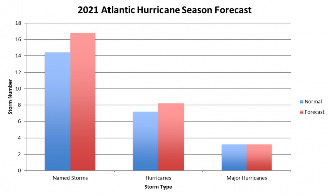
The forecast for the 2021 Atlantic Hurricane Season from June-November shows the likelihood for a near normal season, with
Unlike last season, the 2021 outlook does not include a hyperactive season within the expected range of outcomes, though there is very little chance for below normal activity this season. It should be noted that a “normal hurricane season” now represents higher levels of tropical activity in all aspects because of the climatology update uses 1991-2020 as the baseline instead of 1981-2010 period used previously. If 2021 outlook was issued based on the previous climatology, the forecast would call for an active season instead of a near normal one.
The Greek alphabet will no longer be used to extend the named storms’ list. If all names in the first list have been used, a supplemental list will begin.
Background:
The major ocean basins’ data support a near to above normal season of tropical activity once again. Beginning with ENSO (El Niño Southern Oscillation), there is an 80% chance of neutral or La Niña conditions being in place by the August-October peak of hurricane season, with only a 20% chance of El Niño.
La Niña is the most favorable state for active Atlantic seasons as it supports low vertical wind shear needed for tropical cyclone formation and intensification, so the strong likelihood of neutral or La Niña conditions in 2021 suggests an active year while the slight El Niño chance reduces that potential.
The Atlantic Multi-decadal Oscillation (AMO) shows an 80% chance to be in its favorable warm Sea Surface Temperature (SST) phase for Atlantic tropical activity.
The largest question is the Indian Ocean Dipole (IOD), which has a connection to Atlantic occurrence of dry air that suppresses tropical cyclone formation. In 2021, there are questions about the state of the IOD by August-October, which supports a nearer to normal hurricane season.
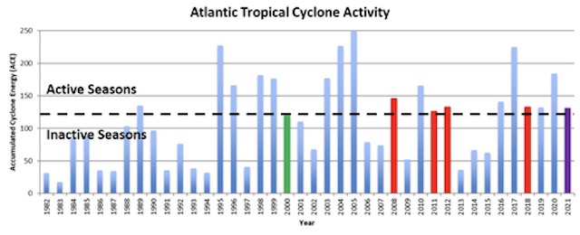
The most reliable forecast variable is Accumulated Cyclone Energy (ACE), which is widely viewed as the best measure of cyclone activity instead of the total named storm number and hurricane number. Since tropical cyclones vary wildly in duration from 1-10+ days, similar numbers of storms in different years can still represent very different levels of activity.
The spread among the storms is relatively narrow, with 20% of the years showing below normal activity while the other 80% showed above normal activity. Due to the narrow range among prior years relative to the new normal level of activity, 100% of the prior years used in the forecast are in the “near normal” range. This results in a high confidence outlook for near to above normal activity in 2021, with the direction of ENSO and the IOD being the key issues to monitor.
The data used in the forecast and current SST anomalies both indicate the U.S. East Coast being at the greater risk for higher impacts than usual, based on warm ocean waters off the coastline. If the model holds, any developing tropical cyclone that moves across the Western Atlantic approaching the U.S. will have ample energy to become a high-impact hurricane if other environmental conditions allow. There is also a consensus for slightly warmer than normal SST around the Leeward Islands of the Caribbean Sea, making that another area to watch for high-end impacts this season. Gulf of Mexico SST is not low but not near the record warmth of last year.
Summary:
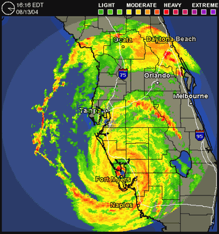
An active 2020 summer storm season passed by Anna Maria Island with minor effects. Hurricane Eta caused a surprisingly high storm surge and flooding overnight coinciding with a high tide. A local business man died from electrocution after touching a flooded appliance.


“I think really what stood out to me about 2020 was the extremely active late season. October and November were extremely active with seven storms and a whopping four major hurricanes (Delta, Epsilon, Eta and Iota).” said Phil Klotzbach, lead author of the forecast at CSU.
The causes of the active year, according to NOAA’s lead seasonal hurricane forecaster Gerry Bell, included warmer-than-average Atlantic sea-surface temperatures and a stronger west African monsoon, along with wind patterns coming off Africa that were more favorable for storm development.
“These conditions, combined with La Niña, helped make this record-breaking, extremely active hurricane season possible.”
While it’s clear warmer ocean temperatures make storms stronger, there’s still vigorous debate among top climate scientists on the question of whether warmer waters lead to a greater number of tropical systems.
“My colleagues and I feel that the jury is very much out on the topic of global tropical cyclone frequency,” said Dr. Kerry Emanuel from MIT, a leading researcher on how climate change affects hurricanes. While this Atlantic season was extreme, he points out that what we see in the Atlantic Basin is not representative of the rest of the globe. “Only about 12 percent of the world’s tropical cyclones occur in the Atlantic, and globally it has not been a very exceptional year.”
Atlantic Hurricane Season | April 2020 forecast | 2020 Actual |
| Named storms (>35mph) | 13 | 30 |
| Hurricanes (>72mph) | 8 | 13 |
| Major hurricanes (>111mph) | 4 | 9 |
| US landfall likelihood | 55% | 40% (12) |
| Gulf Coast landfall | 32% | 30% (9) |
| Florida landfall | 7% (2) Keys and panhandle |
The Named Storms of 2020:
| Name | Active Period | Peak Strength mph |
| TS Arthur | May 16-19 | 60 |
| TS Bertha | May 27-28 | 50 |
| TS Cristobal | June 1-10 | 50 |
| TS Dolly | June 21-24 | 45 |
| TS Edouard | July 4-6 | 45 |
| TS Fay | July 9-11 | 60 |
| TS Gonzalo | July 21-25 | 65 |
| Hurricane Hanna | July 23-27 | 90 (Cat 1) |
| Hurricane Isaias | Jul 28-Aug 5 | 85 (Cat 1) |
| TS Josephine | Aug 11-16 | 45 |
| TS Kyle | Aug 14-16 | 50 |
| Hurricane Laura | Aug 20-29 | 130 (Cat 4) |
| Hurricane Marco | Aug 20-25 | 75 (Cat 1) |
| TS Omar | Aug 31-Sep 5 | 40 |
| Hurricane Nana | Sep 1-4 | 75 (Cat 1) |
| Hurricane Paulette | Sep 7-23 | 105 (Cat 2) |
| TS Rene | Sep 7-14 | 50 |
| Hurricane Sally | Sep 11-18 | 105 (Cat 2) |
| Hurricane Teddy | Sep 12-24 | 140 (Cat 4) |
| TS Vicky | Sep 14-17 | 50 |
| TS Beta | Sep 17-25 | 60 |
| TS Wilfred | Sep 18-21 | 40 |
| TS Alpha | Sep 18-19 | 50 |
| TS Gamma | Oct 2-6 | 70 |
| Hurricane Delta | Oct 4-12 | 145 (Cat 4) |
| Hurricane Epsilon | Oct 19-26 | 115 (Cat 3) |
| Hurricane Zeta | Oct 24-29 | 110 (Cat 2) |
| Hurricane Eta | Oct 31-Nov 13 | 150 (Cat 4) |
| TS Theta | Nov 10-15 | 70 |
| Hurricane Iota | Nov 13-18 | 160 (Cat 5) |


For detailed discussion of factors contributing to 2020 storm weather, see CSU meteorology (pdf).
This year 2020, Sunday, August 23, 8 am to 4 pm at Waterline Marina Resort, 5325 Marina Drive, Holmes Beach.

Donate blood this weekend and help people and animals. Wildlife Inc. is asking for your help in raising money to operate their education and rehabilitation center on Anna Maria Island.
If you have had COVID-19 (SARS-CoV-2) and made antibodies, your donated blood plasma could save lives.
The special blood drive is sponsored by Suncoast Blood who offer a free COVID-19 antibody test, a free T-shirt, and Waterline Resort who are offering a chance to win a weekend stay at the Marina Resort and Beach Club. $100 will be donated to one of three charities that you choose.
Your participation helps fund the non-profit organization Wildlife Inc., which rescues and treats more than 3000 birds, mammals, and reptiles each year and releases as many as possible back into the wild.
For more information see suncoastblood.org or call 866-972-5663

The 2020 extended range tropical forecast has been published by Colorado State University Department of Atmospheric Science.
As at April 2, the forecast is for above average activity for the Atlantic Ocean basin. Sea surface temperatures averaged across the tropical Atlantic are somewhat above normal and potentially expect weak La Niña conditions by this summer or fall.
The forecast predicts an above average probability for major hurricanes making landfall along the continental United States coastline and in the Caribbean.
(full details at
2020 Forecast numbers: